Zahvaljujem se
lordssyndicate i
Anti_Illuminati Global Moderatoru sa Prison Planet foruma na razotkrivanju još jednog od zločina NWO.
U pitanju je još jedna vježba združenih federalnih službi US, pod rukovodstvom FEMA-e, koja je od vježbe prešla u live mode.
Baš kao što je NORAD "slučajno" imao vježbu 9/11, i kao što je 7/7 u Londonu "slučajno" počala vježba koja je isto prešla u live mode, baš kao što je dan prije zemljotresa (dokazana povećana aktivnost HAARP-a u tom periodu) na Haitiu "slučajno" počela vježba FEME za reakciju na prirodne katastrofe. FEMA se kasnije hvalila kako su brzo reagovali u isporuci pomoći Haitiju jer su "slučajno", zbog vježbe koja je bila u toku, imali spakovano na paletama sve što je neophodno.
Ovog puta je "slučajno" u pitanju NLE-10. Info prezentovan u pdf formatu dostavljen je
lordssyndicate sa molbom da izadje u javnost sa njim.
***Exclusive pictures of the Oil Rig False Flag and the War Games preceding it.NOW INFO EXTRACTED FROM A PDF FROM AN INTERNAL SOURCE....
THESE PHOTOS SPEAK FOR THEMSELVES. THIS IS A PRISON PLANET FORUM EXCLUSIVE!
These are NO WHERE ELSE ON THE NET ... THE PDF ITSELF COMES FROM A VERY RELIABLE INTERNAL SOURCE....The PDF Extracted :
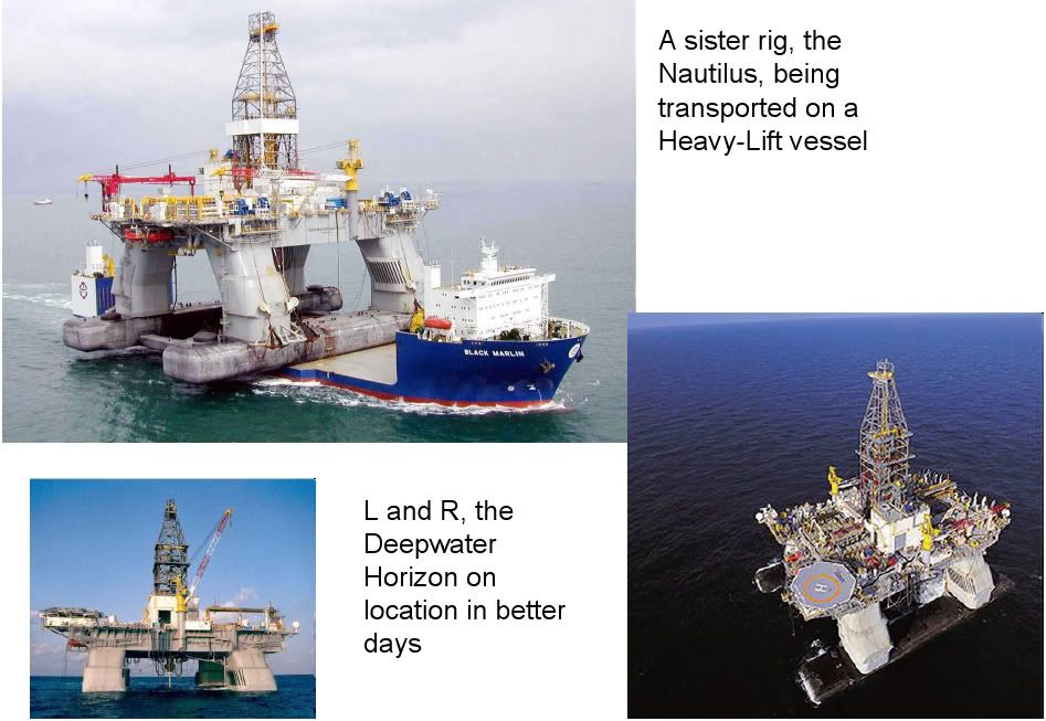
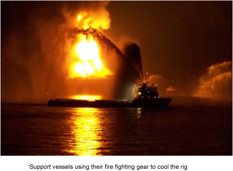
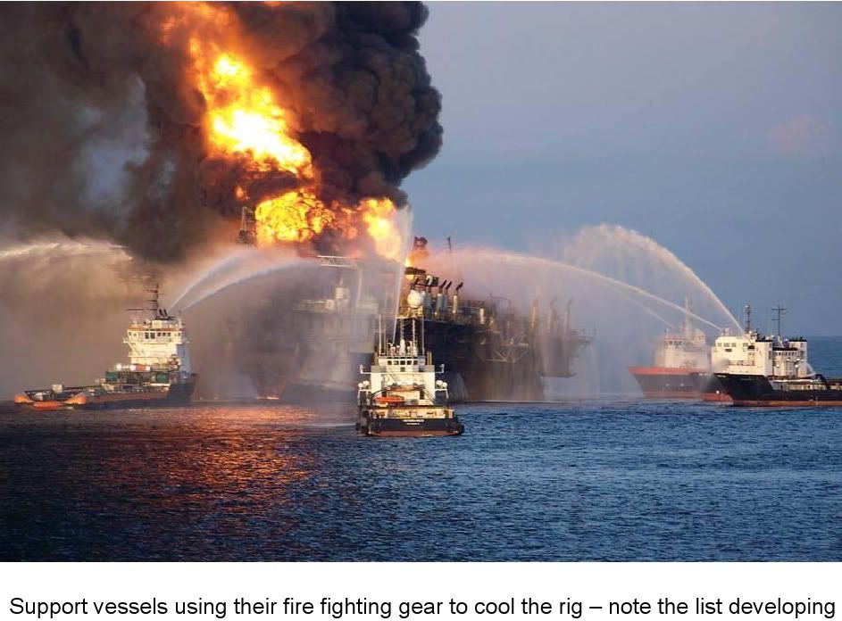
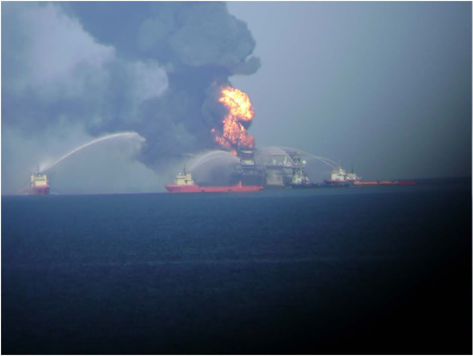
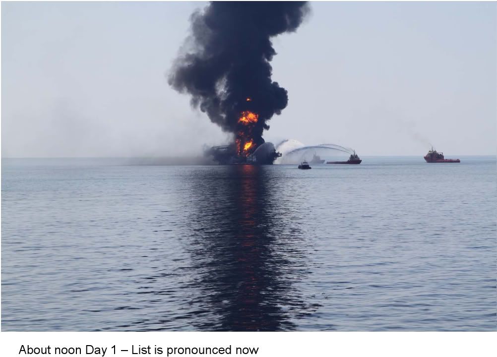
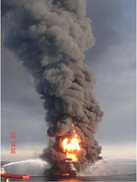
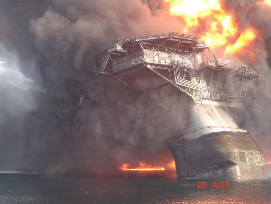
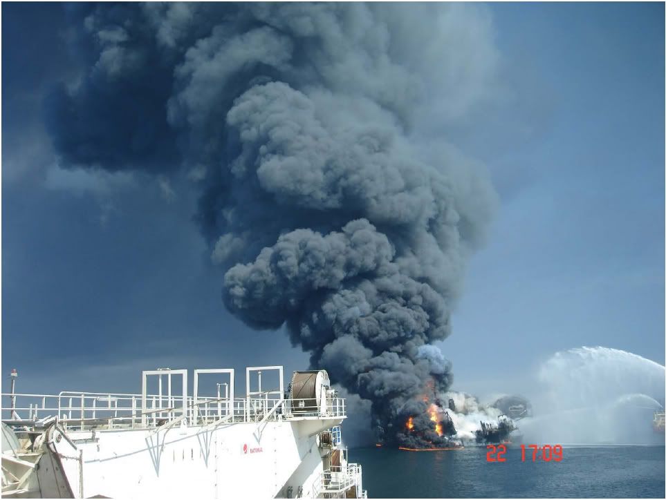
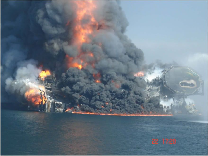
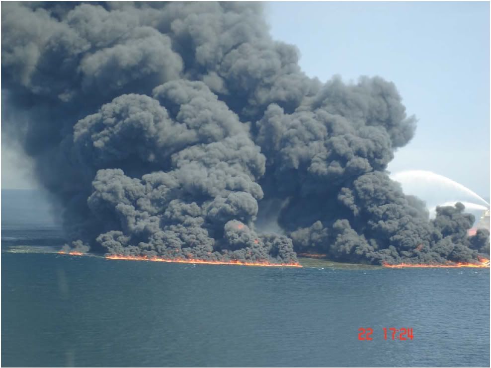
You may have heard the news in the last two days about the Deepwater Horizon drilling rig which caught fire, burned for two days, then sank in 5,000 ft of water in the Gulf of Mexico. There are still 11 men missing, and they are not expected to be found. The rig belongs to Transocean, the world’s biggest offshore drilling contractor. The rig was originally contracted through the year 2013 to BP and was working on BP’s Macondo exploration well when the fire broke out. The rig costs about $500,000 per day to contract. The full drilling spread, with helicopters and support vessels and other services, will cost closer to $1,000,000 per day to operate in the course of drilling for oil and gas.
The rig cost about $350,000,000 to build in 2001 and would cost at least double that to replace today. The rig represents the cutting edge of drilling technology. It is a floating rig, capable of working in up to 10,000 ft water depth. The rig is not moored; It does not use anchors because it would be too costly and too heavy to suspend this mooring load from the floating structure. Rather, a triply-redundant computer system uses satellite positioning to control powerful thrusters that keep the rig on station within a few feet of its intended location, at all times. This is called Dynamic Positioning. The rig had apparently just finished cementing steel casing in place at depths exceeding 18,000 ft. The next operation was to suspend the well so that the rig could move to its next drilling location, the idea being that a rig would return to this well later in order to complete the work necessary to bring the well into production.
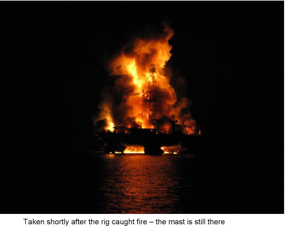
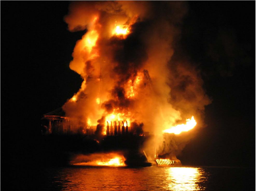
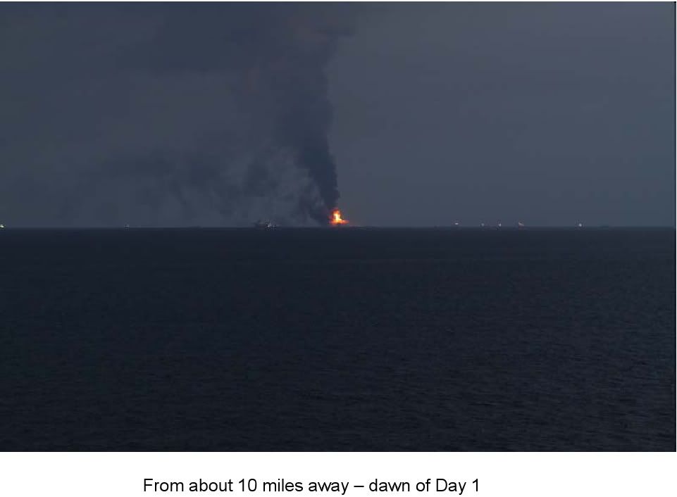
It is thought that somehow formation fluids – oil /gas – got into the wellbore and were undetected until it was too late to take action. With a floating drilling rig setup, because it moves with the waves, currents, and winds, all of the main pressure control equipment sits on the seabed – the uppermost unmoving point in the well. This pressure control equipment – the Blowout Preventers, or ‘BOP’s” as they’re called, are controlled with redundant systems from the rig. In the event of a serious emergency, there are multiple Panic Buttons to hit, and even fail-safe Deadman systems that should be automatically engaged when something of this proportion breaks out. None of them were aparently activated, suggesting that the blowout was especially swift to escalate at the surface. The flames were visible up to about 35 miles away. Not the glow – the flames. They were 200 – 300 ft high.
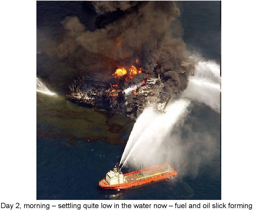
All of this will be investigated and it will be some months before all of the particulars are known. For now, it is enough to say that this marvel of modern technology, which had been operating with an excellent safety record, has burned up and sunk taking souls with it. The well still is apparently flowing oil, which is appearing at the surface as a slick. They have been working with remotely operated vehicles, or ROV’s which are essentially tethered miniature submarines with manipulator arms and other equipment that can perform work underwater while the operator sits on a vessel. These are what were used to explore the Titanic, among other things. Every floating rig has one on board and they are in constant use.
In this case, they are deploying ROV’s from dedicated service vessels. They have been trying to close the well in using a specialized port on the BOP’s and a pumping arrangement on their ROV’s. They have been unsuccessful so far. Specialized pollution control vessels have been scrambled to start working the spill, skimming the oil up. In the coming weeks they will move in at least one other rig to drill a fresh well that will intersect the blowing one at its pay zone. They will use technology that is capable of drilling from a floating rig, over 3 miles deep to an exact specific point in the earth – with a target radius of just a few feet plus or minus.
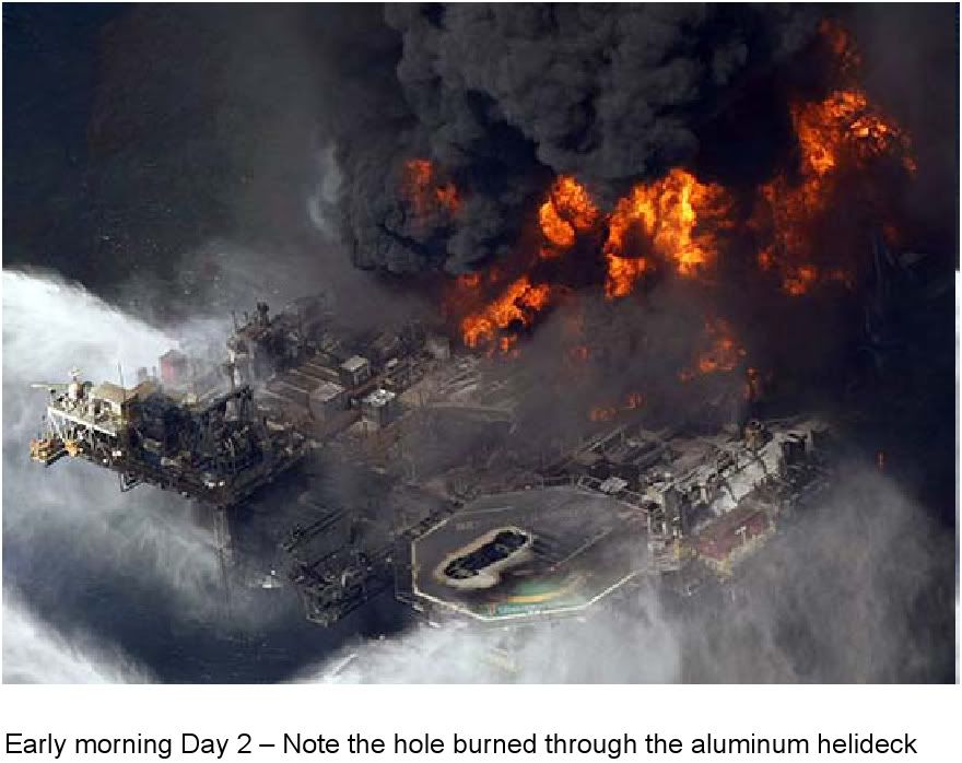
Once they intersect their target, a heavy fluid will be pumped that exceeds the formation’s pressure, thus causing the flow to cease and rendering the well safe at last. It will take at least a couple of months to get this done, bringing all available technology to bear. It will be an ecological disaster if the well flows all of the while; Optimistically, it could bridge off downhole. It’s a sad day when something like this happens to any rig, but even more so when it happens to something on the cutting edge of our capabilities. The photos that follow show the progression of events over the 36 hours from catching fire to sinking.

PROOF THIS IS PART OF NLE !!!!!!!!!!!
http://coastguardnews.com/coast-guard-a ... 010/03/19/ Coast Guard announces SONS 2010 national level exercise
Mar 19th, 2010 by cgnews.
The U.S. Coast Guard and 50 other federal, state and private organizations will conduct the triennial Spill of National Significance Exercise or SONS 2010 from March 22-25 in the northeast region of the U.S.
SONS 2010 is a full-scale exercise designed to test response to a Spill of National Significance. A SONS is a spill that due to its severity, size, location, complexity or impact requires extraordinary coordination of federal, state, local, and responsible party resources to contain and clean up.
As the lead federal agency for pollution incidents in coastal zones, the Coast Guard conducts this type of exercise every three years. Since 1994, exercises have taken place in Pennsylvania., Alaska, Texas, California, and the Midwest.
The Coast Guard’s role in environmental protection dates back more than 175 years to the Timber Act of 1822 that mandated the U.S. Revenue Cutter Service protect government timber from poachers. In 1968, federal roles and responsibilities for oil spill responses were defined by the National Oil and Hazardous Substances Pollution Contingency Plan, also known as the National Contingency Plan. The plan was updated in the early ‘90s, to include the lessons learned from the March 24, 1989 Exxon Valdez oil spill. Today the Coast Guard continues to protect the marine environment as one of its 11 statutory missions.
This year’s exercise will focus on the response to a simulated oil spill affecting the Northeast . The scenario will include a collision between a tanker transporting of 430,000 barrels of crude oil and a car carrier during a severe snowstorm. The simulated collision will occur about 15 miles from shore in the Gulf of Maine. During the response, the tanker will simulate the loss of 69,000 barrels of crude oil while sinking at the entrance to the harbor in Portland, Maine.
“The support of our vital federal, state and local partners, and our industry partner, Shell, has been phenomenal and we expect to have a vigorous and valuable exercise,” said Rear Adm. Paul R. Zukunft, SONS 2010 exercise director. “The lessons we learn together with all our partners will influence national response policy and improvements to the National Response System.”
The SONS Exercise Program has four overarching goals: increasing the preparedness of the entire response organization from the field level up to agency leadership in Washington, DC.; exercising the National Response System at the local, regional, and national levels using a series of large-scale, high probability oil and hazardous material incidents; providing an environment for an unprecedented level of cooperation throughout all levels of government, private sector, and non-governmental organizations; and offering broad opportunities to improve plans and procedures.
SONS 2010 is the only Coast Guard-sponsored Department of Homeland Security Tier II exercise on the Homeland Security Exercise and Evaluation Program five-year calendar. The exercise involves more than 600 members from a variety of federal, state, local, tribal and private organizations.
WHAT THEY DON'T WANT YOU TO SEE ABOUT THE OIL LEAK!
http://www.uscg.mil/comdt/blog/archive/ ... rchive.asp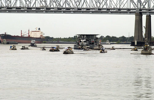
Spill of National Significance SONS 2010 Exercise Begins Today
Guest blog from Captain Anthony Lloyd, Chief, Office of Incident Management and Preparedness
Today, the Coast Guard-sponsored DHS Tier II Spill of National Significance (SONS) 2010 exercise begins. The exercise is based upon a scenario in New England involving a collision between an oil tanker and a car carrier causing a catastrophic oil spill. It is an operations-based, full-scale exercise intended to stress all levels of the response organization.
The Coast Guard National Command Center is leading the way by sending exercise information via electronic alerts to simulate critical communications much like what was implemented during Haitian response operations. Exercise partners include: Transport Canada, Department of Homeland Security, Department of the Interior, Department of Transportation, National Oceanic and Atmospheric Administration, Occupational Safety and Health Administration, National Geospatial-Intelligence Agency, Navy Supervisor of Salvage, National Response Team, Shell Oil Products US, as well as the States of Maine, New Hampshire, Massachusetts, and Rhode Island. Exercise design and execution are major efforts that require the full participation of all partners.
The SONS 2010 Exercise Design Team developed the scenario and scripted actions for the first 48 hours to facilitate a ?warm start.? This approach allows full-scale activities on Day 3 to focus on immediate interaction between the National Incident Commander (NIC), played by RADM Jim Watson, and senior leaders throughout DHS and the NRT departments and agencies, as well as field response in New England.
Scripted products include draft Incident Action Plans and an Area Command Operations Guide representative of the first two response days. The development of these documents generated valuable discussions about Federal On Scene Coordinator authority, organizational elements, the role of the NIC, and response issues such as places of refuge. Lessons learned from these discussions will be included in the exercise After Action Report (AAR) further increasing preparedness throughout the National Response System.
Exercise play begins on March 24th.
 http://www.uscg.mil/comdt/blog/archive/ ... rchive.asp
Wednesday, February 24, 2010
National Oil Spill Response Exercise 2010
Guest blog from LT Kelly Dietrich, USCG
Oil and Hazardous Substance Response Division U.S. Coast Guard Headquarters - Office of Incident Management and Preparedness
The United States Coast Guard is excited to sponsor the 2010 Spill of National Significance (SONS) Exercise which kicks off on March 22th with training, equipment deployment, and exercise play in Portland, ME; Portsmouth, NH; Boston, MA; Portsmouth, VA; and Washington, D.C. This exercise will include on-water use of oil spill response equipment including boom, skimmers, response vessels, and aircraft deployed by Transport Canada, US Coast Guard, US Navy, State, and commercial contractors.
The purpose of SONS 2010 is to implement and stress all elements of oil spill response plans and organizations at the local regional, and national levels in accordance with the National Contingency Plan (NCP) and National Response Framework (NRF). This includes the engagement of the National Incident Commander (NIC), a national level support position responsible for coordination and communication at the national and strategic levels.
The exercise has been designed by over 200 representatives from over 50 participating agencies over the past year. Shell Oil volunteered to support the exercise as the industry Responsible Party. We look forward to a realistic and valuable learning opportunity designed to test and examine the NRS.
Exercise partners include: Transport Canada, Department of Homeland Security, Department of the Interior, Department of Transportation, National Oceanic and Atmospheric Association, Occupational Safety and Health Administration, National Geospatial-Intelligence Agency, Navy Supervisor of Salvage, National Response Team, Shell Oil Products US, as well as the States of Maine, New Hampshire and Massachusetts. Exercise design and execution are major efforts that require the full participation of all partners.
A short photo collage titled Oil Spill Response featuring some images from the Cosco Busan oil spill in San Francisco Bay November 2007.
For more information about the SONS 2010 exercise and past SONS exercises please visit
http://www.SONS2010.com.
______________________________________
SEE BELOW LINK FOR EMBEDDED LINKS:
It looks like they are using this global catastrophe as another one of their real world network centric warfare observation/behavioral analysis laboratories:
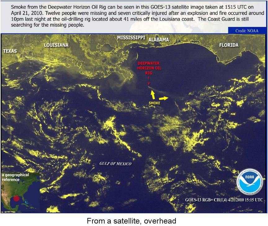
http://www.emergencymgmt.com/disaster/T ... Spill.htmlTechnologies Track Gulf of Mexico Oil Spill, Provide New Views of its Effects
by Jessica B. Mulholland on May 20, 2010
The now-infamous oil leak resulting from an April 20 oil rig explosion had, as of May 17, spewed an estimated 5.7 million gallons of oil into the Gulf of Mexico, according to estimates from a PBS NewsHour widget. With 210,000 gallons flowing into the ocean each day, myriad technologies have been deployed to not only stop the leak, but also to track its devastation and cleanup. The New York Times, for example, has created an interactive map showing where the oil has drifted each day, pulling data from the National Oceanic and Atmospheric Administration and U.S. Coast Guard.
Crowdsourcing — outsourcing tasks to a larger group through an open call — could allow the federal government to get another look at the spill's impact. Using online submissions, texts, tweets and e-mails from those experiencing the spill's effects, the Louisiana Bucket Brigade (LABB), a New Orleans-based environmental health and justice nonprofit, is collecting and posting incident reports on its Oil Spill Crisis Map.
The Oil Spill Crisis Map is based on Ushahidi open source software and produced by students at Tulane University, in conjunction with LABB and Radical Designs. Ushahidi, pronounced "ooh-sha-hee-dee," was initially developed to map incidents of violence and peace efforts throughout Kenya after the post-election fallout in early 2008. LABB already was coding Ushahidi for reporting environmental hazards, and students in Tulane Professor Nathan Morrow's GIS classes helped modify the open source application to track the oil spill.
Morrow said what initially prompted Anne Rolfes, founding director of LABB, to implement the map was that in Louisiana, although citizens can report vague environmental hazards to the state's Department of Environmental Quality (DEQ) online 24 hours a day, 7 days a week, the DEQ only accepts detailed reports via phone from 9 a.m. to 3 p.m., Monday through Friday. "She works with all these communities that want better access to reporting accidents and chemical spills," Morrow said. "And that's how the idea came about — to give these citizens a little more voice, so they could write or text in any time they see an accident or smell a bad odor."
Rolfes added that although there was no restriction on frequency, DEQ's response in general is terrible. "This is one [way] we were going to take matters into our own hands," she said.
Because the architecture for this project already was in place when the oil spill occurred, the focus shifted from general environmental hazard reporting in the state to reporting specifically on the spill. "It was timing and coincidence that the students were still there, still available," Morrow said. "They just took it and inched it up to the application you see now."
To get community participation for populating the map, LABB put out a press release asking citizens to share sightings and other experiences related to the oil spill by text, tweet, e-mail and online submissions. Each eyewitness report requires a description and location information, such as address, city and state, ZIP code or coordinates. Photos and video also can be uploaded via the Web. Citizen reporters can remain anonymous or disclose their contact information.
When users submit reports, the reports are automatically added to the map. LABB has someone on shift every hour to look at those reports and ensure that they're legitimate, Rolfes said, marking them as verified if they're in line with what LABB is hearing from others in the region. "If it's something completely new that we haven't heard," Rolfe said, "we'll either wait to get more reports on the subject or we'll go look in the news and see if it's being reported in the larger media."
The current map at LABB's website is a very early version and will get much better as more functionality is added, Morrow said. "The students are still interested," he said, "and there's a whole lot more you can do with the reporting and the way things are presented and organized."
Crowdsourcing and using open source technology is beneficial in emergencies for a few reasons, Rolfes said. "In the purest sense, it gives a person a voice no matter how rich or poor you happen to be; it allows you to put your situation up on the map for the world to see, and that's really important," she said. "The other important part is that it can share the magnitude of the problem."
With Hurricane Katrina, Rolfes added, no one was recording and collecting people's experiences in one central location. The LABB, she said, thinks the solution is a collective repository, like the Oil Spill Crisis Map.
"We believe it can help inform the emergency response and hold it accountable," Rolfes said. "In some ways this is a work in progress, but we think that by putting all the problems out on the map for all the world to see, it then creates a demand of government and of responders to meet those problems that are expressed."
LABB's efforts are paying off too. After meeting with the organization on May 11, U.S. Environmental Protection Agency Administrator Lisa Jackson wrote on her Facebook wall: "Just wrapped a meeting at Tulane University speaking with scientists and public health experts from four states. Discussed Ushahidi, a crowdsourcing technology from Kenya that is helping people across the community track and report [oil] spill developments."
[Photo courtesy of the U.S. Environmental Protection Agency.]
Re: WHAT THEY DON'T WANT YOU TO SEE ABOUT THE OIL LEAK!
First off thanks AI for the additional articles. As we can See this whole rig being blown was part of an NLE DRILL!!!!!!!!!!!
The PDF is especially damning it shows they let a rig worth over 350 million dollars burn... Why did they not want to salvage any of it? Perhaps it's the same reason that Blackwater and the coast gaurd were given orders no to allow any survivors capable of testifying about it!
This back fired when 1 of the survivors went on NPR and said that they were tortured into signing amnesty agreements and gag orders granting the Government and HALIBURTON / BLACKWATER AMNESTY!
NPR LATER RELASE THIS STREAM O ALL THINGS CONSIDERED AFTER HEAVY EDITING AS A PIECE BLAMING BP FOR NOT LETTING THE SURVIVOR CONTACT HIS WIFE!!!!!!!!!
WTF !!!!!!!!!!!!!!!!!!!!
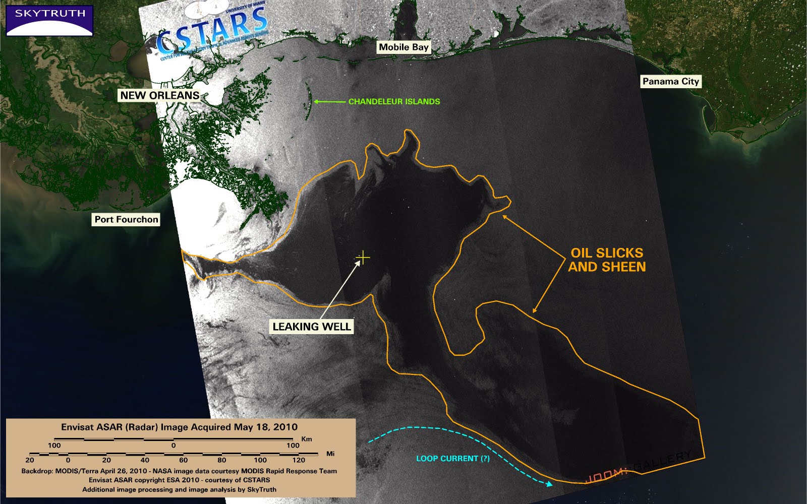
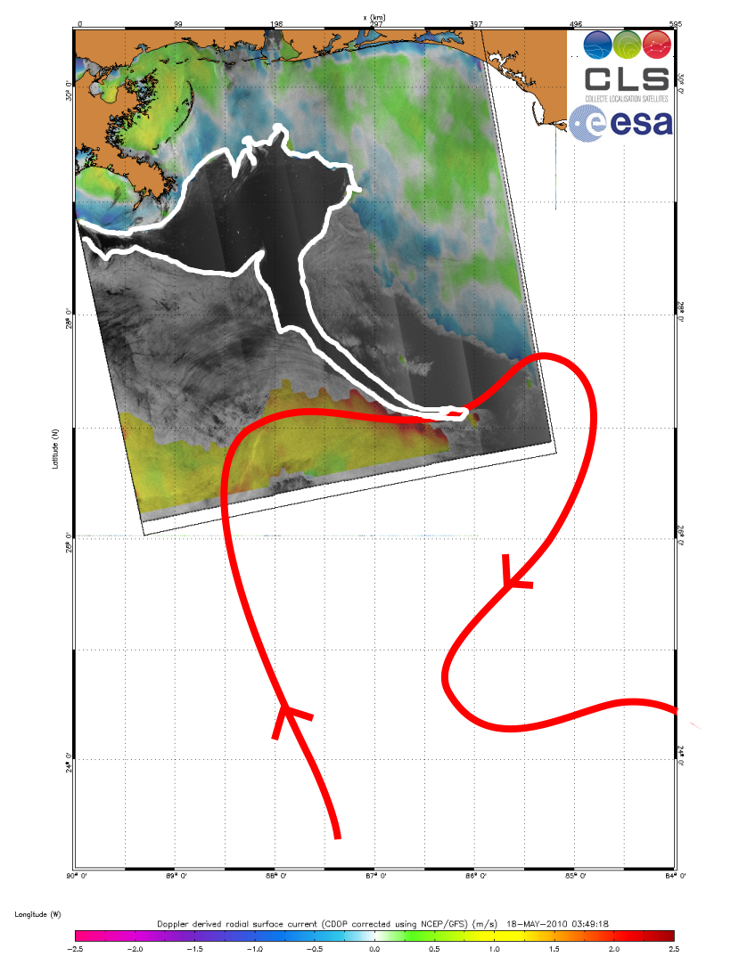
Apparently it has now been sucked into the currents of the gulf, and it is traveling rapidly from the well site.
Good Article puts a lot in perspective
http://www.fishnet-usa.com/FishAndOil.htm


](./images/smilies/eusa_wall.gif "Brick wall")